538
538
Nov 30, 2012
11/12
by
KOFY
tv
eye 538
favorite 0
quote 0
winter storm warning for the sierra nevada could see 2 to 3 feet of snow before 8500 feet. this is going until 4:00 p.m. tomorrow. carry the chains if you brave the weather. accu-weather 7 day forecast it's going to be messy for the morning commute. that's when the strongest part of the wind rain possibly thunder get in hear then the third system will bring heavy rain wind possibly thunder sunday morning. >> okay thanks very much. >> well california is now a player in power ball. state lottery commission voted unanimously today to start the game next april. this decision comes rate on the heel of last night 5 87 million dollar power ball jackpot drawing. 2 wing tickets were sold. one in dearborn, missouri the other in fountain hills, arizona. the the there will be a news conference to announce the missouri winner tomorrow apparently. the winners could take the a lump sum payment of about 192 million dollars each before taxes. so if you don't have the winning power ball numbers, no problem. here are 3 residence why it may good that you didn't win the lotter lottery. lotto wi
winter storm warning for the sierra nevada could see 2 to 3 feet of snow before 8500 feet. this is going until 4:00 p.m. tomorrow. carry the chains if you brave the weather. accu-weather 7 day forecast it's going to be messy for the morning commute. that's when the strongest part of the wind rain possibly thunder get in hear then the third system will bring heavy rain wind possibly thunder sunday morning. >> okay thanks very much. >> well california is now a player in power ball....
132
132
Nov 30, 2012
11/12
by
KOFY
tv
eye 132
favorite 0
quote 0
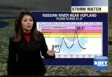
look at the sierra nevada some of the highest elevation starting to l and state route 4. strong winds morning commute. rain continues on saturday and it's stormy on sunday with flooding possible so let's get rate to the storm. it's a very large circulation. thing that concerns me about this one is it's slow moving. look at the moisture it stretches all the way out across the pacifica. sub tropical moisture bill only allow the rainfall to linger. so it is slow moving and soake soaker. 11:00 p.m. tonight heaviest rain in the north bay as you can see here. computer animation takes you in. 4 a.m. we see the heaviest rain folk news the north bay. slow goin going. by 6:00 a.m. barely shift into the east bay. down towards the south bay and at 8:00 a.m. it's intense. continue to see strong gusty win. of course lightning is possible. isolated thunderstorms. we head into 10:00 a.m. hasn't moved a whole lot we are concerned about flooding issues. noon time we start to notice that they have rain in the east bay south bay and starting to get a little bit of a let up in the north bay.
look at the sierra nevada some of the highest elevation starting to l and state route 4. strong winds morning commute. rain continues on saturday and it's stormy on sunday with flooding possible so let's get rate to the storm. it's a very large circulation. thing that concerns me about this one is it's slow moving. look at the moisture it stretches all the way out across the pacifica. sub tropical moisture bill only allow the rainfall to linger. so it is slow moving and soake soaker. 11:00 p.m....
188
188
Nov 30, 2012
11/12
by
KGO
tv
eye 188
favorite 0
quote 0
look at the sierra nevada some of the highest elevation starting to l and state route 4. strong winds morning commute. rain continues on saturday and it's stormy on sunday with flooding possible so let's get rate to the storm. it's a very large circulation. thing that concerns me about this one is it's slow moving. look at the moisture it stretches all the way out across the pacifica. sub tropical moisture bill only allow the rainfall to linger. so it is slow moving and soake soaker. 11:00 p.m. tonight heaviest rain in the north bay as you can see here. computer animation takes you in. 4 a.m. we see the heaviest rain folk news the north bay. slow goin going. by 6:00 a.m. barely shift into the east bay. down towards the south bay and at 8:00 a.m. it's intense. continue to see strong gusty win. of course lightning is possible. isolated thunderstorms. we head into 10:00 a.m. hasn't moved a whole lot we are concerned about flooding issues. noon time we start to notice that they have rain in the east bay south bay and starting to get a little bit of a let up in the north bay.
look at the sierra nevada some of the highest elevation starting to l and state route 4. strong winds morning commute. rain continues on saturday and it's stormy on sunday with flooding possible so let's get rate to the storm. it's a very large circulation. thing that concerns me about this one is it's slow moving. look at the moisture it stretches all the way out across the pacifica. sub tropical moisture bill only allow the rainfall to linger. so it is slow moving and soake soaker. 11:00 p.m....
200
200
Nov 30, 2012
11/12
by
KGO
tv
eye 200
favorite 0
quote 0
look at the sierra nevada some of the highest elevation starting to l and state route 4. strong winds morning commute. rain continues on saturday and it's stormy on sunday with flooding possible so let's get rate to the storm. it's a very large circulation. thing that concerns me about this one is it's slow moving. look at the moisture it stretches all the way out across the pacifica. sub tropical moisture bill only allow the rainfall to linger. so it is slow moving and soakeld so it is slow moving and soaker. 11:00 p.m. tonight heaviest rain in the north bay as you can see here. computer animation takes you in. 4 a.m. we see the heaviest rain folk news the north bay. slow goin going. by 6:00 a.m. barely shift into the east bay. down towards the south bay and at 8:00 a.m. it's intense. continue to see strong gusty win. of course lightning is possible. isolated thunderstorms. we head into 10:00 a.m. hasn't moved a whole lot we are concerned about flooding issues. noon time we start to notice that they have rain in the east bay south bay and starting to get a little bit of
look at the sierra nevada some of the highest elevation starting to l and state route 4. strong winds morning commute. rain continues on saturday and it's stormy on sunday with flooding possible so let's get rate to the storm. it's a very large circulation. thing that concerns me about this one is it's slow moving. look at the moisture it stretches all the way out across the pacifica. sub tropical moisture bill only allow the rainfall to linger. so it is slow moving and soakeld so it is slow...
SFGTV2: San Francisco Government Television
99
99
Nov 30, 2012
11/12
by
SFGTV2
tv
eye 99
favorite 0
quote 0
redding, we'll be calling on organizations outside the state of california that we have mou's with out of nevada and other surrounding states so that in the event an incident of this magnitude happens there is sufficient response personnel notified postured and deployed to keep a continuous line of assistance from the private municipal sector moving into the stricken area in san francisco to support and reconstitute those life lines across all disciplines, telecommunication, water, waste water, gas and energy. >> thank you. mr. brig. >> good afternoon. when we talk about resill yepbs and resiliency for the san francisco public works, the sfpuc not only provides those life lines to san francisco, but we also operate the hetch hetchy regional water system that supplies a great amount of water for a large part of the bay area, 2 1/2 million customers. and for a regional supplier like ourselves when resiliency comes sbat conversation you are talking about earthquakes come up already and terrorism as well and we've done a lot to put our money where our mouth is. we are right in the middle of investin
redding, we'll be calling on organizations outside the state of california that we have mou's with out of nevada and other surrounding states so that in the event an incident of this magnitude happens there is sufficient response personnel notified postured and deployed to keep a continuous line of assistance from the private municipal sector moving into the stricken area in san francisco to support and reconstitute those life lines across all disciplines, telecommunication, water, waste water,...
226
226
Nov 30, 2012
11/12
by
KPIX
tv
eye 226
favorite 0
quote 0
the play of the daytimes five. >>> very stormy day here in the sierra nevada. lots more snow coming in that direction. let's check your snow report. winter storm warnings across the high country. heavenly 6" in the last 24 hours and more to come. kirkwood, bring the chains, pretty high base on the snow levels about 7,000 feet. but very windy conditions in the high country. northstar 7" of new snow and plenty more to come. more on your weather when we come back. ♪ [ engine revs ] ♪ ♪ [ male announcer ] the mercedes-benz winter event is back, with the perfect vehicle that's just right for you, no matter which list you're on. [ santa ] ho, ho, ho, ho! [ male announcer ] lease a 2013 c250 for $349 a month at your local mercedes-benz dealer. >>> hi-def doppler showing a major storm sliding through the bay area right now. heavier rainfall in parts of the south and east bay. be prepared. you could see some flooding on the roads. >>> it is just not doing good things for the morning commute. chp just checked, covering about 80 different incidents all across the ba
the play of the daytimes five. >>> very stormy day here in the sierra nevada. lots more snow coming in that direction. let's check your snow report. winter storm warnings across the high country. heavenly 6" in the last 24 hours and more to come. kirkwood, bring the chains, pretty high base on the snow levels about 7,000 feet. but very windy conditions in the high country. northstar 7" of new snow and plenty more to come. more on your weather when we come back. ♪ [ engine...
175
175
Nov 30, 2012
11/12
by
KGO
tv
eye 175
favorite 0
quote 0
friday in sierra, nevada. we're expecting two to four feet below 8500 feet. carry your chains if you are heading to tahoe. stormy in the morning for the teirn bay area. stormiest shifts to the south an east. temperatures in the upper 50s to mid-60s for friday afternoon. it's going be rough go getting out of town tomorrow. it really doesn't end then. it continues right through the weekend. >> carolyn: thanks. >> larry: a new york city police officer's act of kindness has sparked a sensation. they took the cellphone picture giving new boots to a homeless man. she saw the officer giving the man boots and socks. she posted the image on the police department's facebook page tuesday night and since then it's an instant hit. she wanted everybody to see what he witnessed. >> he had boots in his hand. i heard him, i have size 12 all leather boots for you. let's take care of you. the gentleman sat down against the wall. his face lit up. he smiled. >> he said he keeps the receipt into his vest that no matter how bad his day seems, there are other people that have it muc
friday in sierra, nevada. we're expecting two to four feet below 8500 feet. carry your chains if you are heading to tahoe. stormy in the morning for the teirn bay area. stormiest shifts to the south an east. temperatures in the upper 50s to mid-60s for friday afternoon. it's going be rough go getting out of town tomorrow. it really doesn't end then. it continues right through the weekend. >> carolyn: thanks. >> larry: a new york city police officer's act of kindness has sparked a...
185
185
Nov 30, 2012
11/12
by
KPIX
tv
eye 185
favorite 0
quote 0
high country we are looking at winter storm warnings there in the sierra nevada. above 7,000 feet could see upwards of another 12" of snow. and some gusts to 70 miles per hour. so if you are going to head up there be careful and, of course, take the chains. next few days, this stormy weather will continue on and off. the potential for flooding will continue right on in through the weekend. looks like we catch a break come monday. but more showers possible next tuesday and wednesday. boy, it is tough out there on the roads, elizabeth. >> i know. if you can stay home, do it. we are getting new problems just coming in. we'll get to the bay bridge in just a minute. first we'll talk about this traffic alert. westbound 580 blocked at the dublin interchange. super slow through pleasanton. we can't even calculate the drive time right now traffic at a standstill. at last check it was a half hour between the altamont pass and the dublin interchange westbound 580 lanes. but again, all lanes are blocked. there was an oil spill, big rig accident around 1:50 this morning. and t
high country we are looking at winter storm warnings there in the sierra nevada. above 7,000 feet could see upwards of another 12" of snow. and some gusts to 70 miles per hour. so if you are going to head up there be careful and, of course, take the chains. next few days, this stormy weather will continue on and off. the potential for flooding will continue right on in through the weekend. looks like we catch a break come monday. but more showers possible next tuesday and wednesday. boy,...
157
157
Nov 30, 2012
11/12
by
KTVU
tv
eye 157
favorite 0
quote 0
stretching from sear's point back over to nevada. that can be heavy rain. i think they had appear inch of reason ha 45 minutes at the boardwalk. you bonk and small stray -- labs like the heavier rain is steve to moving out. san jose north where some of that line has been. this kind of pattern, snow grade just keeps going over to pleasanton, livermore, dublin, haywood and up toward memoryville. out to the south bay. looks like highway 4 around antioch, oakley action brentwood, discoverer bay. starting to pick up. general rain, berkeley, oakland, san francisco, little bit no marin, mill valley, kempsville. that's where it's starting to pick up. there is just so much moisture, some of the rain goes through but the cloud cover isn't. this will about he with us all day. flash booed watches. looks like between now and sun. thursday through sunday time frame the forecast was maybe about ten inches, i think that will come through because of more rain on saturday and another on sunday. >> thank you. today the united states court may decide the fate of proposition 8,
stretching from sear's point back over to nevada. that can be heavy rain. i think they had appear inch of reason ha 45 minutes at the boardwalk. you bonk and small stray -- labs like the heavier rain is steve to moving out. san jose north where some of that line has been. this kind of pattern, snow grade just keeps going over to pleasanton, livermore, dublin, haywood and up toward memoryville. out to the south bay. looks like highway 4 around antioch, oakley action brentwood, discoverer bay....
 Live Music Archive
 Librivox Free Audio
 Metropolitan Museum
 Cleveland Museum of Art
 Internet Arcade
 Console Living Room
 Books to Borrow
 Open Library
 TV News
 Understanding 9/11